



Author: Stewart Berry
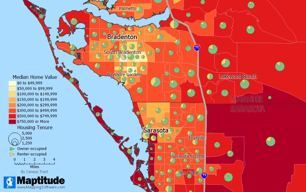
Maptitude, a G2-designated Leader in GIS, maps home values and housing tenure from the included Census data
18 November 2026
In 2026, real estate mapping software continues to play a vital role in how agents, brokers, appraisers, investors, and commercial real estate teams judge a location. From desktop GIS for real estate with Census data built in to property intelligence platforms, the tools on the market do very different jobs.
Real estate teams use them to answer clients’ questions about a neighborhood, compare commercial sites, screen a metro area for new locations, and show listings on a map. With this many tools on the market, the choice is not obvious. Before deciding, you should evaluate which features are offered, the pricing, and any advantages or disadvantages.
This page compares 10 real estate mapping platforms. Most link to their own independent profile, and each has buttons that run a comparison against Maptitude on the AI tool of your choice. We will start by explaining what real estate mapping software is and the key features that define a strong tool. Or use the table of contents to skip straight to the platforms.
Testimonials Features Free Trial
In this article:
What Is Real Estate Mapping Software?
Key Features of Real Estate Mapping Software
10 Real Estate and Property Mapping Software Compared for 2026
What Teams Use Real Estate Mapping Software For
Which Real Estate Mapping Software Is Right for Your Business?
It puts property on a map. Real estate mapping software shows listings, sites, and clients on a map, along with data about the area around them. Type an address and you go straight to the right spot on the map.
It answers questions about a neighborhood. Is the site near major roads? Are there schools nearby? Is the income level right for first-time buyers? Are there parks or other amenities nearby? What is the range of home values? These are just a few of the questions a map made with Maptitude can answer.
It measures the differences between sites. For commercial property, it reports the population and income around each site, shows where competitors are, and compares sites to one another both by location and by demographics.
It analyzes, not just displays. The stronger tools geocode your address lists, draw drive-time rings, plan field routes, and pick good locations from a set of candidates.
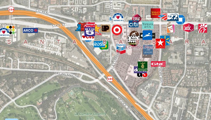
Streets and named landmarks are included, and you can switch the map background to aerial imagery
That makes it useful across the industry:
These are the questions to ask about every tool you look at, and how Maptitude answers each one:
Here are 10 real estate mapping platforms, each with a link to its independent profile and AI comparison tools so you can evaluate it against Maptitude yourself.
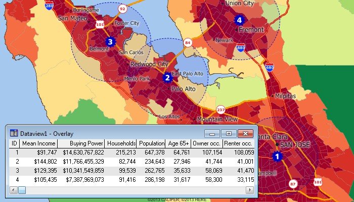
Site analysis with the included Census data. The map and table show the people living within five miles of several locations
Maptitude puts your listings, sites, and clients on a map, with neighborhood demographics, streets, and landmarks included.
Third-party recognition. Maptitude has been named a Leader in GIS on G2 in 27 reports since 2018, and is rated 4.7 out of 5 from 150 verified reviews on G2. It was named a Top Software Product in the G2 2026 Best Software Awards, placing in the top 0.63% of all vendors. G2 reviewers score it 9.2 out of 10 for Quality of Support. It has also been named a Champion by Info-Tech Research Group and SoftwareReviews, and recognized by Gartner Digital Markets across Capterra, Software Advice, and GetApp. See all Maptitude awards.
Maptitude real estate features:
Pricing. Maptitude is sold with or without an annual subscription (see current prices). Each license includes one Country Package of maps and data at no extra charge. It has an up-to-date street layer for geocoding, travel times for routes and drive-time rings, building footprints for many urban locations, named landmarks, postal data, and detailed demographics where available. Geocoding is unlimited, with no per-use charges. Extra data layers are add-ons. Some, such as the USA traffic count layer, are free downloads for current users, and some are sold separately.
Maptitude offers a free 30-day trial with full functionality and no credit card required, so you can start mapping now.
Webinar: Using Maptitude for Real Estate. This webinar demonstrates how you can map your clients and sites, create drive-time rings to visualize coverage, calculate the distance and travel times from your sites to your clients, and create optimized routes to service your clients.
Use the buttons below to get an independent AI comparison of Maptitude and Maptitude Online against the other platforms on this page:

|
“Maptitude is a great program. As a real estate appraiser who primarily values commercial properties, I have found the functions and data provided a great benefit in showing clients what is going on in a specific area. Features such as exporting data to MS Excel which can be put in my reports.” Bruce Ownby |

|
“Maptitude is critical for providing information in commercial real estate location selection. Maptitude is a very versatile GIS system which is able to produce a wide variety of maps economically.” Louis Scudere |

|
“I have access to traffic counts, local businesses, demographic information, drive times, and aerial imagery, all at the tips of my fingers. The program is easy to use, as well.” Kellye Martin |

|
“We have tried different software and had almost given up. Maptitude is by far the most effective software and at a reasonable price for a business like ours (FavTrip). The staff is amazing and always willing to help out.” Babir Sultan |

|
“I started the Research Dept where I work and needed a GIS. Not wanting to ask for a lot of money in the startup dept, I found Maptitude. I was able to purchase it at a great price. It is also easy to learn for anyone with other GIS experience.” Kyle Kretsinger |
Source: Wikipedia – ArcGIS
See Wikipedia for a current description of ArcGIS.
For a current, independent description of ArcGIS Pro, see their profile on G2, and compare it to Maptitude: g2.com/compare/maptitude-vs-maptitude-online-vs-arcgis-pro →
Use the buttons below to get an independent AI comparison of Maptitude vs ArcGIS Pro:
Use the buttons below to get an independent AI comparison of Maptitude vs DealMachine:
Source: Wikipedia – Google Earth
See Wikipedia for a current description of Google Earth.
For a current, independent description of Google Earth Pro, see their profile on G2, and compare it to Maptitude: g2.com/compare/maptitude-vs-maptitude-online-vs-google-earth-pro →
Use the buttons below to get an independent AI comparison of Maptitude vs Google Earth Pro:
For a current, independent description of Land id, see their profile on G2, and compare it to Maptitude: g2.com/compare/maptitude-vs-maptitude-online-vs-land-id-formerly-mapright →
Use the buttons below to get an independent AI comparison of Maptitude vs Land id:
For a current, independent description of LandVision, see their profile on G2, and compare it to Maptitude: g2.com/compare/maptitude-vs-maptitude-online-vs-landvision →
Use the buttons below to get an independent AI comparison of Maptitude vs LandVision:
For a current, independent description of Mapme, see their profile on G2, and compare it to Maptitude: g2.com/compare/maptitude-vs-maptitude-online-vs-mapme →
Use the buttons below to get an independent AI comparison of Maptitude vs Mapme:
For a current, independent description of PropStream, see their profile on G2, and compare it to Maptitude: g2.com/compare/maptitude-vs-maptitude-online-vs-propstream →
Use the buttons below to get an independent AI comparison of Maptitude vs PropStream:
For a current, independent description of Reonomy, see their profile on G2, and compare it to Maptitude: g2.com/compare/maptitude-vs-maptitude-online-vs-reonomy →
Use the buttons below to get an independent AI comparison of Maptitude vs Reonomy:
Use the buttons below to get an independent AI comparison of Maptitude vs Salesforce Maps:
These examples come from Maptitude customers and from maps made with Maptitude:
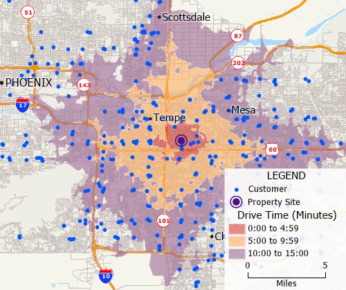
Drive-time rings show how many customers can reach each proposed site
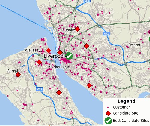
The Facility Location Wizard picks good locations from a set of candidate sites
Open-source mapping tools such as QGIS can be powerful, and many organizations use them effectively. However, Maptitude is a professionally developed commercial application, first released in 1995, with commercial-grade demographic and street data included. Every Maptitude feature is built into one product. There are no paid plugins to buy for added functionality, and no third-party components that each need their own security review. Because it is not open source, and every feature is built into one product, it is trusted in security-sensitive industries such as government, healthcare, and financial services.
Maptitude gives you mapping, demographics, and analysis in one product, with or without an annual subscription. Streets, landmarks, building footprints, and Census demographics are included, with unlimited geocoding and no per-use charges.
It works for a single agent answering questions about a neighborhood, and for a team comparing commercial sites across a metro. FavTrip has no GIS staff. Its CEO learned Maptitude himself during the free trial, with help from support and training sessions, and was running selections on his own data within weeks.
Try it on your own listings or sites with the free 30-day trial, with full functionality and no credit card.
Learn more about Maptitude real estate mapping to see how you and your team can benefit!
Schedule a Free Personalized Demo
It is software that shows properties, listings, and sites on a map together with data about the area around them, such as population, income, home values, roads, and schools. Agents use it to answer questions about a neighborhood, and commercial teams use it to compare sites.
Maptitude adds analysis on top of the map: geocoding, drive-time rings, routing, and the Facility Location Wizard for choosing sites.
Maptitude is sold with or without an annual subscription, with one Country Package of street, landmark, and demographic data included and no per-use charges. See current Maptitude prices.
Yes. Maptitude includes Census demographics, so you can map home values and housing tenure, or find areas with many young children, more retirees, higher income, or more owner-occupied housing. See the data included with Maptitude.
Yes. Maptitude maps addresses from Excel and the other file types it reads, over 50 in all, with no limit on the number of records. Once your listings are on the map, you can filter them by location or by attributes such as price range or number of rooms.
Put the sites on a map, then report the demographics within a set distance or drive time of each one. Maptitude does this with the included Census data. You can import competitor locations and count how many sit within a mile of each site, and count how many customers can reach each site within each drive-time band.
To suggest new sites, the Facility Location Wizard picks good locations from a set of candidates. See site location with Maptitude.
Yes. The USA traffic count layer is a free download for the current version of Maptitude with the USA Country Package. It shows the annual average daily traffic (AADT) on each road. In the FavTrip case study, FavTrip tagged every point in a grid over greater Kansas City with annual average daily traffic counts, and kept only locations with at least 10,000 vehicles a day.
Yes, if you have a parcel layer. If your county parcel files come as Esri Shapefiles or another format Maptitude reads, you can add them to any map. Maptitude reads more than 100 GIS and CAD formats. The Massachusetts assessor’s office in the property inspection case study loaded statewide MassGIS parcel maps and geocoded every property address.
Yes. Maptitude is a geographic information system (GIS) that includes street maps, landmarks, and Census demographics. An appraiser in Fort Lauderdale uses it to show clients what is going on in an area, and a Massachusetts assessor’s office uses it to plan parcel inspections. See Maptitude for real estate.
Yes. Maptitude and Maptitude Online each have a free 30-day trial with full functionality and no credit card. Students and educators can use both free for one year. Start the Maptitude trial.

 Check out our G2 Reviews

Third-party trademarks are used for identification and descriptive purposes and do not imply affiliation or endorsement. See Third-Party Trademarks.

Home | Products | Contact | Secure Store
 Call Us


