
Author: Stewart Berry
19 September 2025
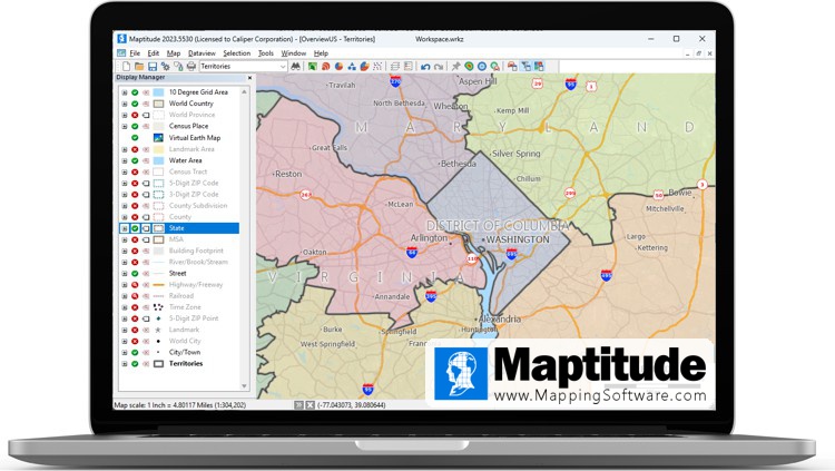
Is your organization looking for sales territory mapping software and wondering which brand is the best? Are you tired of being deceived by "top 10" product reviews that don’t use real customer testimonials? If so, and you need help deciding which brand to buy (and which to avoid), keep reading. Below is the most comprehensive overview of the tools available.
Territory realignments face typical software project issues. 20% of such projects fail and over 52% face major challenges. Only 22% are successful.1 But you can limit issues by picking the right brand.
When you make the right choice the benefits of territory mapping are clear and have the potential to hugely improve your sales numbers, through:
In this guide, I reveal the most highly rated territory alignment applications. I also share what features users and researchers rate highest, so you know which apps to avoid. I use independent 3rd party review sites to allow you to pick the right product.
To determine the most recommended territory applications, I analyzed data from consumers to get a true perspective.
Wherever possible, I used validated users of the GIS (geographic Information System) brands mentioned in this guide. Nothing speaks to this topic more clearly than people who own these brands and use them regularly.
I’ve taken time to analyze hundreds of reviews from sites like G2 and Capterra to provide a balanced view of what business users think. I link directly to these websites to allow you to compare the products yourself.
Territory mapping applications are a type of GIS (Geographical Information Software). Most reviews are for GIS and are not specific to territory mapping. This reduces the number of reviews available in this sub-category.
I identified two sites specifically covering this topic: SourceForge and SoftwareAdvice. They both allow sorting by average rating. The only brand featuring in the top 5 of both lists is Maptitude. Maptitude is ranked in first place on SourceForge. Only one other product, RealZips, was reviewed and had a single response.
More mapping software reviews are available when not limited to territory apps. Capterra and G2 are popular review sites. When sorting by highest rated, Maptitude is again in the top 5. Top-rated products appearing on multiple sites included:
G2 allows you to compare products side-by-side. I looked at the products for the top-ranking vendors. You can see that the ratings are quite close for the four offerings. However, Maptitude consistently has the highest scores for “Features.”
These competitors mention territory tools on their websites: Esri/ArcGIS/ArcMaps, Carto, and Maptitude. The next highest G2 ranked products that have territory functionality are: MapInfo Pro and QGIS.
SoftwareReviews takes a deep dive into how users feel about mapping brands. Each year they publish their Geographic Information Systems Emotional Footprint Awards. Hexagon GeoMedia and Maptitude received multiple best GIS (Geographic Information System) awards.
However, GeoMedia does not appear to have territory functionality. The reviews available did not mention territories. Also, searching on ‘hexagon geomedia "sales territories"’ returned no relevant results.
Maptitude was classified as a “Champion” according to the comprehensive online survey. SoftwareReviews' Net Emotional Footprint measures high-level user sentiment. It aggregates emotional ratings from 26 questions, creating an indicator of the overall user feeling toward a product. Maptitude received a Net Emotional Footprint of +80 and exceeded user expectations in being trustworthy. In general, GIS users were most satisfied with vendors providing remarkable service experiences.
Maptitude was also a 2022 SoftwareReviews Gold Medal Award winner, being recognized as an outstanding vendor in the technology marketplace as evaluated by users. Gold Medals are the capstone of an in-depth software evaluation report, and awarded using a proprietary, transparent methodology. This composite satisfaction score averages four different areas of evaluation: Net Emotional Footprint, Vendor Capabilities, Product Features, and Likeliness to Recommend.
The Capterra buying guide makes one mention of territories. They note that “an enterprise or premium product that is priced higher may include additional features such as advanced market analysis tools, sales territory hierarchy, and advanced map sharing.”
You must check the software price for hierarchies if you want to map districts and sales regions.
The Sales Management Association (SMA)2 conducted a survey on sales territory design. Based on the answers, it is advisable that the chosen application provide:
According to research3, mapping software failure has three causes. The mapping brand chosen can help avoid these pitfalls.
The application should minimize the learning of new skills. You should ask, does the territory tool:
Managing external data sources can cause project failure. At a minimum, diverse data tables should easily open. Ideally, most of the data required should be provided as part of the purchase.
The application should not be hard to use. You should ask, does the territory tool make it easy to:
Problems accessing and using software can cause project failure. At a minimum the chosen territory design platform should allow online sharing. Ideally, most of the features required should be wizard driven to simplify the process.
The application should not require unique IT support. Training should be minimal. You should ask, does the territory tool:
Unusual technology requirements can cause project failure. At a minimum a Windows style interface should be provided. Ideally, single document management should be supported: GIS systems are notorious for complex file management issues4. Also, Cloud access to maps would allow operating system independence.
The range of features available in a districting app can be daunting and makes it hard to assess what is truly important. Here are some of the major items you need to have on your checklist.
To get started quickly there should be a Setup Wizard for importing region, county, or postal data directly into a new territory layer. The typical steps supported should be to:
Sales area mapping software allows you to create overlapping territories. You can then visualize them with an "edge-based" color theme.
A Territory Manager helps you modify your alignments without having to learn a whole new interface. There should be a dedicated toolbar that allows you to:
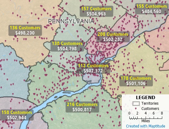
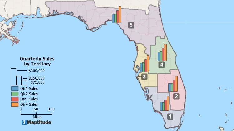
Sales territory mapping by ZIP Code. Grouping ZIP Code territories balanced by sales, customers, population, or other values. Maptitude territory optimization software.
Automatic territory creation tools simplify the territory building process by reducing the initial hands-on effort required. Territories can be balanced to have equal numbers of customers, sales, population, etc. Methods include:
Territory mapping software should be able to automatically create balanced territories from groups of features |
Territory planning software should automatically cluster and organize features into compact groups |

|
“We use Maptitude extensively for running complex Territory Alignment scenarios. The depth of the product, its total utility and functionality is immense. Import-Export capability with Excel is seamless. It is easy to work with and Maptitude support is second to none. My complements to the Maptitude team: They have created a solid product and it is one of the best software investments we have made as an organization.”
|
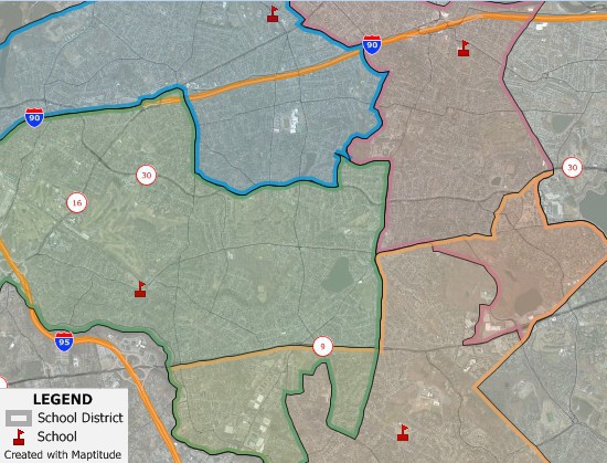
An automized street-based territory tool provides advanced zone creation capabilities. Rather than abstract areas, the actual roads travelled are used to create alignments. Territories can be created around locations using the:
Sales representatives can then visualize market assignments, market coverage, and lists of locations, all based on travels costs.
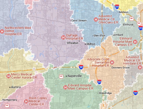
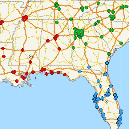
Territory management software includes a territory mapping tool for creating street-based territories. The map shows the shortest travel time zones to various hospitals.

|
“A wonderful territory mapping program and then some! Ease of moving territories, obtaining census data and plotting territories to that data. Beautiful interface and several ways to customize the product and exports. The ability to pull in my older MapPoint files and data was a huge plus! Great video tutorials that help you get started as well.”
|
Territories may cover multiple countries or even the entire world. If so, the product needs to be able to create international territory maps. Supported features must include the ability to select/lasso entire countries or sub-national geographies such as provinces or postal boundaries.
Create territories from any level of geography within a country |
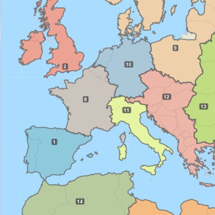
Create territories from countries on a global scale |
These tools can actually be perfectly reasonable for many applications. They are included in this section simply because they have characteristics that may hamper territory management over time. This may be especially true in comparison to methods that use geographic boundaries that neatly cover the whole country, such as counties or postal boundaries.
Circular rings (buffers) and drive-time zones can be used to define sales territories. Such “rings” can be hard to manage when they overlap because it causes problems for managing reps and customers. Also, because they are not based on postal/ZIP Codes, it can be difficult to explain the territories to others. Circular rings are great analytical tools but are less useful for managing territories.
Another problematic territory method is areas of influence (Thiessen Polygons or a Voronoi Diagram). These are based on straight-line or “as the crow flies” distance. They automatically determine the closest area to each facility, but ignore barriers such as buildings and natural features. They create simple service areas that can show under or over-served locations, but they do not consider the locations that can actually be reached when driving or walking.
A third method is manual editing. These tools allow the user to create, add, move, or split areas by drawing boundary lines. It is also possible to add and edit areas by copy-pasting lines from features such as roads, railroads, or rivers. This method allows the most customization and flexibility. However, as with rings, they may be hard to share with others. They can also be time consuming to create and manage. Some franchise businesses use metes and bounds reports to describe the outer boundary of each territory.
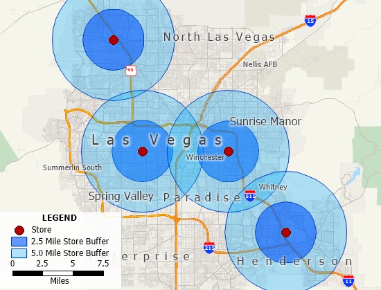
Circular rings showing areas 2.5 and 5 miles around store locations
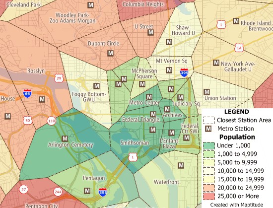
Straight-line distance territory mapping tool identifies areas that are under or over-served with simplified territories.
Providing fair and balanced "protected" territories is important. This is especially true in the franchise industry. Franchises must:
Territory mapping software must track and balance unlimited territory characteristics. This supports establishing, justifying, and defending profitable territories.
 How CKE Grew Their Business with Maptitude
 |
“Maptitude just works! We now build our franchise territories with ease. Our organization has benefited from our ability to strategically plan out prospective territories, gauge market penetration of our active franchise territories, and begin to identify what our top performing territories have in common.”
|
Maptitude territory software provides tools for creating territories for business mapping. Maptitude empowers sales teams with robust territory management software. Maptitude is a professional territory map creator. Extensive geographic and demographic data is included. This allows you to start creating territories immediately. Many other mapping and GIS software packages require you to buy data separately.
The Maptitude sales territory mapping tools provide easier ways to create new territory plans. This is important because effective territories mean higher sales. Maptitude achieves this by automatically creating fair and equitable territories for your salespeople.
Maptitude is a versatile territory planning solution. The software provides the sales tools and software tools that sales managers need.
 |
“We are able to do things with Maptitude that we had not dreamed of doing before (using MapPoint and Territory Mapper). There are so many possibilities, that you can easily create a mapping solution that perfectly meets the need of your business model.”
|
Sales territory mapping Excel/sales territory mapping Google Maps
Sales territories or market areas can consist of groups of postal zones, counties, or other regions that a business uses to manage a larger overall market. Businesses use sales territories to manage sales representatives. Fair and balanced sales territories help maximize revenue by providing equal sales opportunities to salespeople.
Sales territory map software can map territories from smaller areas, such as states and provinces, with your data attached.
Sales territory mapping software is an application for visualizing, balancing, and analyzing sales territories using maps. Sales territory management can be complex, and the visual nature of maps simplifies the process. Sales territory mapping software allows you to share your territory alignments and to create graphics such as heat maps of revenue by salesperson.
You can use sales territory map software to create territories based on:
It is also possible to create overlapping territories or territories based on streets. Your territories can be saved in many formats (e.g., Shapefile, Oracle Spatial, or SQL Server Spatial).
The benefits of sales territory mapping software are being able to:
Top 10 statistics on why you should align your territories:
 “Companies we have worked with have estimated that poor alignment costs them between
2%-7% of sales.
For many companies millions of dollars are being forfeited each year due to territory inequities.”
“Companies we have worked with have estimated that poor alignment costs them between
2%-7% of sales.
For many companies millions of dollars are being forfeited each year due to territory inequities.”
Andy Zoltners
“Sales Territory Alignment:
An Overlooked Productivity Tool”
Northwestern University Kellogg School of Management
Sales territory planning is the process of defining, mapping, and assigning regions to salespeople to efficiently cover all sales prospects within a company's or organization's market. Equitably balancing opportunities between reps helps manage the logistics of serving territories, as well as providing a way to assess high performers and to analyze sales commissions. A territory map is one of the most essential components of a sales strategy and is the basis for effective planning.
Territory mapping tools define the area boundaries used to manage a salesforce. Examples of territory mapping tools include:
Manual territory mapping tools are often time intensive map-based methods for drawing sales areas. A planner or analyst can draw, trace, or pick lines on a map. Typically, existing areas such as postal or ZIP Codes are not used. Often, streets, natural features such as rivers, and other landmarks are used to define the territories.
Point-and-click territory mapping tools allow areas such as postal or ZIP Codes to be added to a sales territory by clicking on a map. Examples include being able to:
The rules for territory assignments can be defined, such as whether:
Automated territory mapping tools build balanced territories using mathematical models. Existing territories and neighboring areas can also be automatically readjusted to have equal values. For example, building franchise territories tracks the population or target prospects living in each area so that each has the same total values. Often an acceptable threshold is used since it is very hard to have exactly equal numbers.
Here is my list of the top 11 best software for sales territory mapping based on an analysis of real user reviews.
The best sales territory mapping software is an application that meets the needs of the sales organization. The main differences between products for managing territories are:
The best territory program provides a suite of tools that are designed to make it easy to create territories for businesses. A territory map maker should provide detailed geographic and demographic information that allows an analyst to start building territories immediately.
Sales territory planning and management software must provide:
Maptitude sales territory mapping software provides you with a suite of tools that are designed to make it easy to create territories for businesses. Maptitude empowers sales teams with robust software for managing territories.
Unlike other mapping and GIS software that come with limited to no data, Maptitude is a territory map maker that provides detailed geographic and demographic information, allowing you to start building territories immediately.
Sales territory mapping software is used to build territories. The main steps in the process are:
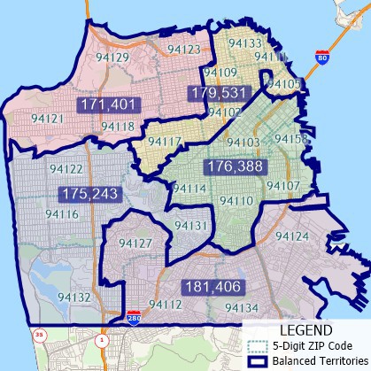
For completed territories, Excel reports list the ZIP Codes that comprise each territory as well as the customers, revenue, sales, opportunities, etc., in each market.
The following is a step-by-step guide for using sales territory mapping software. There are also several territory videos that you can view.
Use the “Create-a-Map Wizard” to create a geocoded point layer of your customers on a map.
Start the “Territory Wizard.” Use the geocoded point layer or the Excel file to create the territories. Balance the total customer sales in each territory. Choose other variables, e.g., population, number of households, or disposable income. Maptitude adds the territories to your customer map and opens the Territory Manager. The territories tab displays the territories list and the total sales. This is for all the customers located in each territory.
Some of the territories may have “holes” in them. Holes are often ZIP Codes that were not in your Excel file because there were no customers located there. To fix the holes, use the selection/lasso tools. These allow you to click on the holes in the territory to select the underlying ZIP Codes.
Adjust the territories so that the sales totals are more balanced. Track how the sales totals for the territories change. This happens as you move ZIP Codes from one territory to another.
The final task is to update the customers with their new territories.
Learn more about Maptitude to see how you and your team can benefit from mapping software!
Schedule a Free Personalized Demo
See also: Sales Mapping Software
Sources:
1 Albrecht, Jochen. "GIS Project Management."
(2018). (Date accessed: Dec. 6, 2022)
2 “SMA Research Findings:
10 Important Territory Planning Statistics.” n.d. Xactly. Accessed
December 13, 2022.
https://www.xactlycorp.com/blog/sma-research-findings-territory-planning-statistics.
3 Birks, David F., Syed Nasirin, and S. H. M. Zailani. "Factors
influencing GIS project implementation failure in the UK retailing
industry." International Journal of Information Management 23, no. 1
(2003): 73-82. (Date accessed: Dec. 6, 2022)
4 Gimond, Manuel.
n.d. Chapter 3 GIS Data Management | Intro to GIS and Spatial
Analysis. Mgimond.github.io.
https://mgimond.github.io/Spatial/gis-data-management.html.
 Check out our G2 Reviews

Home | Products | Contact | Secure Store

