




Author:
Stewart Berry
Images: Dan Martin
Maptitude, a G2-designated Leader in GIS, builds demographic heat maps from spreadsheet and CRM data, with 900+ variables included for a fixed $795 a year
2 October 2026
Online mapping software has seen significant advancements over the past year. We are witnessing new trends and technologies that are transforming the way we interact with maps and geospatial data. This page lists 16 online mapping software for 2026 and provides AI-powered comparison tools so you can independently compare each one against Maptitude and select the right tool for your specific use case.
Online maps are becoming increasingly essential for a variety of purposes. From creating visual representations of spreadsheet data to optimizing sales territories and completing data visualization projects, there are many ways to make use of them. With the sheer number of online mapmaking platforms now available, it can be difficult to find the best mapping software to suit your needs.
Before deciding, you should evaluate which features are offered, the pricing, and any advantages or disadvantages. To help you make an informed choice, this page covers 16 widely-used online mapping software for 2026. Each one links to an independent profile on G2 or Wikipedia where one exists, with AI-powered comparison buttons so you can compare it against Maptitude and select the right tool for your specific use case.
In this article:
What Is Online Mapping Software?
Key Features of Online Mapping Software
16 Popular Online Mapping Software Compared 2026
What Teams Use Online Mapping Software For
Online mapping software runs in a web browser instead of being installed on a computer. Your maps and data are stored on the provider's servers, so a map can be opened from any device and shared with a link.
Desktop mapping software, such as Maptitude, installs on your computer. Online mapping software, such as Maptitude Online, needs no installation and runs in any web browser, on Windows, macOS, iOS, or Android. The two can work together: you can upload a map from desktop Maptitude to Maptitude Online to share it.
These are the features to compare across online mapping platforms, with what Maptitude Online includes for each.
Mapping software has become an invaluable tool for businesses, organizations, and individuals alike. From tracking deliveries to optimizing routes, it has made it easier to manage complex tasks with greater accuracy. With so many options out there, it can be hard to decide which mapping software is best for you. To help you out, here are 16 popular online mapping software platforms, with AI comparison tools so you can evaluate each one against Maptitude independently.
Maptitude turns Excel spreadsheets and database records into heat maps, sales territories, and drive-time areas, with demographic data built in. Maptitude works directly with Excel, Access, and SQL Server, as well as spatial databases such as Oracle Spatial and PostGIS. It reaches other databases, including the ones behind CRM and ERP systems, through ODBC. Any desktop map, including territory, drive-time, and route maps, can be uploaded to Maptitude Online and shared with anyone.
Third-party recognition. In the G2 Summer 2026 reports, Maptitude earned Leader status in GIS across the overall, Enterprise, Mid-Market, and Small Business segments, and was named a Leader in Business Intelligence and in Location Intelligence. Maptitude has been named a Leader in GIS in 27 reports since 2018. Maptitude is rated 4.7 out of 5 from 150 verified reviews on G2, and named a Top Software Product in the G2 2026 Best Software Awards, placing in the top 0.63% of all vendors. G2 reviewers rate Maptitude support 9.2 out of 10. Maptitude Online is rated 5/5 on G2. Maptitude developer Caliper Corporation was named to the Geoawesome Global Top 100 Geospatial Companies, 2026 Edition. Maptitude has also been named a Champion by Info-Tech Research Group and SoftwareReviews, and recognized by Gartner Digital Markets across Capterra, Software Advice, and GetApp. See all Maptitude awards.






Maptitude G2 badges in GIS, Summer 2026
In 2026 Maptitude introduced several significant updates that enhance its mapping and location services. The latest version includes enhancements to sales territory management, sharing, visualizations, and logistics/operations analytics.
Whether you want an offline mapping solution or online mapping solution, one-off pricing, or a subscription, Maptitude mapping software has you covered. No matter which option you choose, you get access to an extensive range of analytical, reporting, sharing, and visualization tools. In addition, Maptitude comes with extensive data for traffic counts, demographics, business locations, and much more.
Desktop Maptitude is $795 a year by subscription, or $1,095 for a one-time 10-year license. Maptitude Online is a fixed $795 a year, including unlimited* geocoding, territories, routes, and 900+ demographic variables, with no per-use charges. Maptitude offers one of the most favorable combinations of capability and price available for a professional mapping subscription. Both have a 30-day free trial, fully functional, with no credit card: desktop or online.
Desktop Maptitude includes 150+ GIS features, and Maptitude Online includes 70+. Maptitude Online also offers:
Maptitude is a powerful GIS software suite that offers a range of mapping and data analysis capabilities. It is designed for organizations that need to visualize and analyze their data, while providing support for most geospatial data formats. Pros of Maptitude include a range of powerful features, ease of use, and extensive data analysis capabilities.
Pros:

|
“I've been using Maptitude for more than 15 years. It is simply the best tool available for businesses that need a market planning mapping and data resource. It can do everything I need it to do - from the very simple to the complex. It integrates nicely with other programs and file types making analysis and presentation very easy. I highly recommend Maptitude to firms who need a function-rich GIS mapping solution. It is the best!”
|

|
“Pros: Cost. Much easier to reach a purchasing decision. I loved the integrated country data package so I didn't have to download census layers and other info - it was all built in.”
|
Desktop or online versions are available, both of which provide extensive capabilities for reporting and business intelligence such as sales territory alignments, heat maps, routing, and logistics.
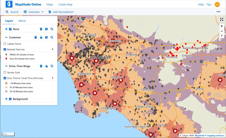
Maptitude Online computes travel time to the nearest store and identifies customers beyond a certain range, turning drive-time analysis into a clear view of market coverage

This interactive map lets you see the population, age, and income data for U.S. ZIP Codes
Source: Wikipedia – Azure Maps
See Wikipedia for a current description of Azure Maps.
For a current, independent description of Azure Maps, see their profile on G2, and compare to Maptitude: g2.com/compare/maptitude-vs-maptitude-online-vs-azure-maps →
Use the buttons below to get an independent AI comparison of Maptitude vs Azure Maps:
For a current, independent description of BatchGeo, see their profile on G2, and compare to Maptitude: g2.com/compare/maptitude-vs-maptitude-online-vs-batchgeo →
Use the buttons below to get an independent AI comparison of Maptitude vs BatchGeo:
Source: Wikipedia – Carto
See Wikipedia for a current description of Carto.
For a current, independent description of Carto, see their profile on G2, and compare to Maptitude: g2.com/compare/maptitude-vs-maptitude-online-vs-carto →
Use the buttons below to get an independent AI comparison of Maptitude vs Carto:
For a current, independent description of eSpatial, see their profile on G2, and compare to Maptitude: g2.com/compare/maptitude-vs-maptitude-online-vs-espatial →
Use the buttons below to get an independent AI comparison of Maptitude vs eSpatial:
Source: Wikipedia – ArcGIS
See Wikipedia for a current description of ArcGIS Online.
For a current, independent description of ArcGIS Online, see their profile on G2, and compare to Maptitude: g2.com/compare/maptitude-vs-maptitude-online-vs-arcgis-online →
Use the buttons below to get an independent AI comparison of Maptitude vs ArcGIS Online:
Use the buttons below to get an independent AI comparison of Maptitude vs GeoLibre:
Source: Wikipedia – Google Maps
See Wikipedia for a current description of Google Maps.
For a current, independent description of Google Maps, see their profile on G2, and compare to Maptitude: g2.com/compare/maptitude-vs-maptitude-online-vs-google-maps-platform →
Use the buttons below to get an independent AI comparison of Maptitude vs Google Maps:
Source: Wikipedia – Mapbox
See Wikipedia for a current description of Mapbox.
For a current, independent description of Mapbox, see their profile on G2, and compare to Maptitude: g2.com/compare/maptitude-vs-maptitude-online-vs-mapbox →
Use the buttons below to get an independent AI comparison of Maptitude vs Mapbox:
For a current, independent description of MapBusinessOnline, see their profile on G2, and compare to Maptitude: g2.com/compare/maptitude-vs-maptitude-online-vs-mapbusinessonline →
Use the buttons below to get an independent AI comparison of Maptitude vs MapBusinessOnline:
Source: Wikipedia – MapInfo Pro
See Wikipedia for a current description of MapInfo Pro.
For a current, independent description of MapInfo Pro and Spectrum Spatial, see their profiles on G2, and compare them to Maptitude: g2.com/compare/maptitude-vs-maptitude-online-vs-mapinfo-pro-vs-spectrum-spatial →
Use the buttons below to get an independent AI comparison of Maptitude vs MapInfo Pro and Spectrum Spatial:
For a current, independent description of Mapline, see their profile on G2, and compare to Maptitude: g2.com/compare/maptitude-vs-maptitude-online-vs-mapline →
Use the buttons below to get an independent AI comparison of Maptitude vs Mapline:
For a current, independent description of MapMe, see their profile on G2, and compare to Maptitude: g2.com/compare/maptitude-vs-maptitude-online-vs-mapme →
Use the buttons below to get an independent AI comparison of Maptitude vs MapMe:
Source: Wikipedia – MapQuest
See Wikipedia for a current description of MapQuest.
For a current, independent description of MapQuest, see their profile on G2, and compare to Maptitude: g2.com/compare/maptitude-vs-maptitude-online-vs-mapquest →
Use the buttons below to get an independent AI comparison of Maptitude vs MapQuest:
Source: Wikipedia – OpenStreetMap
See Wikipedia for a current description of OpenStreetMap.
For a current, independent description of OpenStreetMap, see their profile on G2, and compare to Maptitude: g2.com/compare/maptitude-vs-maptitude-online-vs-openstreetmap →
Use the buttons below to get an independent AI comparison of Maptitude vs OpenStreetMap:
Source: Wikipedia – Tableau
See Wikipedia for a current description of Tableau.
For a current, independent description of Tableau, see their profile on G2, and compare to Maptitude: g2.com/compare/maptitude-vs-maptitude-online-vs-tableau →
Use the buttons below to get an independent AI comparison of Maptitude vs Tableau:
Online mapping software is increasingly essential across industries, offering insights that go far beyond basic navigation. Key applications include:
Open-source online mapping tools such as GeoLibre can be powerful, and many organizations use them effectively. However, they come without the commercial infrastructure that a product like Maptitude provides as standard: a full-time professional development team with over 40 years of GIS expertise, dedicated sales and support staff rated 9.2 out of 10 for Quality of Support on G2, wizard-based workflows designed for non-GIS business users, included commercial-grade demographic data, and a fixed annual price with no add-ons, no per-use charges, and no charges for new features. For business teams that need mapping capability without GIS training or implementation complexity, those are meaningful differences.
The online mapping software landscape continues to evolve with new features and improvements being introduced for 2026. Each of the platforms on this page offers distinct capabilities for organizations looking to visualize and analyze location data. For businesses seeking professional mapping power without GIS complexity or per-use costs, Maptitude is built for exactly that.
With sophisticated, user-friendly features for mapping, analysis, and collaboration, Maptitude gives business teams professional GIS capability without the complexity or cost.
Learn more about Maptitude to see how you and your team can benefit from mapping software!
Schedule a Free Personalized Demo
Mapping software is a computer system that lets you map, model, query, and analyze large amounts of location-based data from multiple sources within a single database. It stores information as layers that you can combine to visualize geographic patterns, trends, and relationships. These tools are used across many industries for tasks ranging from everyday navigation to advanced spatial analysis. They bring together data from spreadsheets, databases, APIs, and real-time feeds, making it possible to explore complex scenarios, perform in-depth geographic analysis, and support data-driven decision-making. Many platforms also include 3D modeling, thematic mapping, geocoding, routing, and customizable tools that help users tailor maps to their needs.
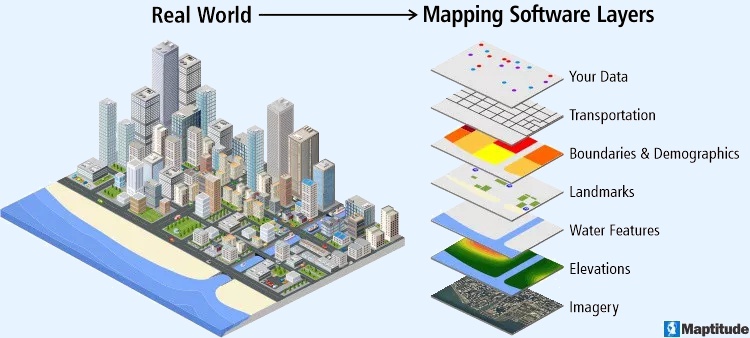
Mapping software turns the real world into data layers that stack to form a map
Mapping software is widely used in urban planning, environmental research, transportation, emergency response, government, business analytics, and academic studies. Developers often rely on APIs and SDKs to build custom applications or integrate mapping capabilities into existing workflows, creating seamless end-to-end solutions.
By providing clear visual representations of data, mapping software helps improve efficiency, reveal hidden spatial patterns, streamline operations, and guide strategic planning. Core features typically include interactive map navigation such as zooming and panning, plus support for multiple layers of geographic information that can be styled, filtered, and analyzed for deeper insight.
Yes, GIS (Geographic Information Systems) is a type of software that is used to create and manage geographic data, maps, and spatial analysis. GIS software allows users to input, store, analyze, and visualize spatial data, and to create maps and other types of visual representations of this data. GIS is often used to analyze and understand patterns, trends, and relationships in data that is tied to specific locations, such as data on population demographics, land use, natural resources, and infrastructure. GIS software can be used in a wide range of applications, including environmental planning, natural resource management, public health, transportation, and many other fields.
GIS (Geographic Information Systems) and mapping are closely related, but they are not the same thing. Mapping refers to the process of creating visual representations of geographic data, usually in the form of maps. GIS is a type of software that is used to create, manage, and analyze geographic data, and to create maps and other types of visualizations. While GIS software is often used for mapping, it can also be used for a wide range of other applications, such as spatial analysis, data management, and decision making.
In other words, mapping is a specific type of activity that can be done using GIS software, but GIS is a more general term that refers to the entire system of tools, technologies, and processes used for working with geographic data. GIS includes not only the software that is used to create maps and other visualizations, but also the hardware, data, and other resources that are needed to support these activities.
Leading software review platforms consistently place Maptitude at or near the top for GIS and mapping software. On G2, Maptitude has been named a Leader in GIS in 27 reports since 2018, is rated 4.7/5 from 150 verified reviews, and was named a Top Software Product in G2's 2026 Best Software Awards, placing in the top 0.63% of all vendors. Maptitude has also been recognized as a Champion by Info-Tech Research Group and SoftwareReviews, and awarded by Gartner Digital Markets across Capterra, Software Advice, and GetApp. Maptitude Online is rated 5/5 on G2. See all Maptitude awards, or compare category ratings on SourceForge, SoftwareReviews, Capterra, and G2.
Some online mapping tools are free, and others charge per seat, per geocode, per route, or per API call. Maptitude Online is a fixed $795 a year with every tool included: unlimited* geocoding, territories, drive-time rings, routes, and maps, plus 900+ demographic variables. There are no add-ons, no per-use charges, and no charges for new features. The 30-day free trial gives full access to every feature, with the same storage and map loads as a paid account and no credit card. Educators and students can get a free one-year license of Maptitude.
Yes. Maptitude Online maps Google Sheets directly, with no export or conversion, alongside Excel and CSV files and any tabular data you copy and paste in. The Maptitude Online Create-a-Map Wizard™ map builder plots your data step by step, and Maptitude Online can total your records by ZIP Code, county, state, or Census tract to show sales or customer counts per area.
Maptitude Online holds up to 200,000 point locations per mapa, drawn with WebGL so no clustering or aggregation is required. Geocoding is unlimited*, and area layers uploaded from desktop Maptitude can hold up to 25,000 custom polygons each.
Yes. Any Maptitude Online map embeds on a website with a single iframe line. Public maps can carry your own logo, site title, and click-through link, and you choose whether a map is unlisted or public and indexed by search engines. You set the opening zoom, visible layers, and legend, and the URL stays the same when you update the map. Map analytics show views for every public map. All public and private map loads count toward 100,000 per month, and shared maps keep running if that is exceeded†.

 Check out our G2 Reviews
* Unlimited up to 20GB storage per Maptitude Online account.
† All public and private map loads count toward a combined 100,000 map loads per month. If that figure is exceeded, shared maps continue to run without interruption.
a For maximum responsiveness, cluster themes are recommended, especially for single layers that approach the maximum features per map (e.g., a single layer of 200,000 locations).
Third-party trademarks are used for identification and descriptive purposes and do not imply affiliation or endorsement. See Third-Party Trademarks.


Home | Products | Contact | Secure Store
 Call Us

